 Belgium Postal codes
Discover Belgium Postal Codes across Regions and Provinces. Instantly retrieve Belgium Postal codes with interactive Postal code lookup Map.
The Belgium postal code system serves as a fundamental aspect of the nation's mail delivery infrastructure, enabling the precise routing and timely delivery of mail and parcels to various regions and municipalities across the country. Comprising numeric sequences, these postal codes are not merely strings of numbers; they are vital tools that organize the logistics of mail distribution, ensuring efficient operations within Belgium's postal network. This page provides an in-depth exploration of the Belgium postal code system, including its format, historical development, and implementation.
To find a comprehensive list of Postal codes in Belgium, please refer to the table below or click on any location on the Interactive map to instantly find the postal code and address for your mail's destination:
List of Postal codes in Belgium
| Province | Region | Postal codes (Range) | Count |
|---|---|---|---|
| Anvers | Vlaanderen | 2000 to 2990 | 161 |
| Brabant Flamand | Vlaanderen | 1500 to 3473 | 239 |
| Brabant Wallon | Wallonie | 1300 to 1495 | 121 |
| Bruxelles | Bruxelles-Capitale | 1000 to 1210 | 22 |
| Flandre-Occidentale | Vlaanderen | 8000 to 8980 | 253 |
| Flandre-Orientale | Vlaanderen | 9000 to 9992 | 309 |
| Hainaut | Wallonie | 6000 to 7973 | 468 |
| Liège | Wallonie | 4000 to 4990 | 374 |
| Limbourg | Vlaanderen | 3500 to 3990 | 220 |
| Luxembourg | Wallonie | 6600 to 6997 | 239 |
| Namur | Wallonie | 5000 to 5680 | 375 |
Interactive Map of Belgium Postal codes
Interactive Postal code lookup Map: Simply click on any location on the map to instantly reveal its Postal code and address details. For a more immersive experience, engage Fullscreen mode to maximize your exploration capabilities and enable smooth navigation with scroll gestures.
Format of Belgium Postal Codes:
Belgium postal codes are exclusively numeric, typically ranging from four to five digits in length. Structured hierarchically, each digit within the code denotes a specific level of geographic granularity. The initial digit often signifies a broader regional area, while subsequent digits narrow down the location to precise municipalities or localities.
For example, the postal code "1000" corresponds to the Brussels-Capital Region, encompassing Brussels and its surrounding municipalities. As the digits progress, such as in "1030" or "1050," they pinpoint specific districts or neighborhoods within the broader region. This hierarchical organization facilitates efficient sorting and routing of mail within Belgium's postal system.
History of Belgium Postal Codes:
The inception of the Belgium postal code system traces back to the mid-20th century, driven by the necessity for a standardized addressing system amidst urbanization and population growth. Before postal codes, mail sorting and delivery relied heavily on manual processes, leading to inefficiencies and delays, especially in urban areas.
In response, Belgium implemented its postal code system in the 1960s, following the footsteps of other European nations like France and Germany. The introduction of postal codes aimed to streamline mail processing, enhance delivery accuracy, and accommodate the country's changing urban landscape.
Over the years, the postal code system underwent refinements to adapt to evolving demographics, administrative boundaries, and technological advancements. These updates ensured the system's relevance and effectiveness in meeting the demands of an increasingly interconnected society.
Implementation of Belgium Postal Codes:
Implementing the Belgium postal code system involved a collaborative effort among postal authorities, government agencies, and stakeholders at various levels. Key steps included:
- Design and Standardization: Postal authorities devised a standardized format for postal codes, ensuring uniform application nationwide. Guidelines for assigning codes considered population density, administrative divisions, and logistical needs.
- Public Awareness: Extensive public awareness campaigns informed residents, businesses, and institutions about the new postal code system. Informational materials, outreach events, and training sessions for postal workers facilitated the transition.
- Infrastructure Upgrades: Upgrades to postal facilities, sorting centers, and equipment were made to accommodate increased mail volume and improve sorting efficiency. Investments in automation technology and data management systems modernized postal infrastructure.
- Integration with Addressing Systems: Postal codes were integrated into existing addressing systems, complementing street names, house numbers, and locality identifiers. This integration facilitated incorporation into address databases, sorting algorithms, and delivery routes.
- Ongoing Maintenance: Regular updates and adjustments to postal codes ensured accuracy amidst demographic shifts and administrative changes. Collaboration with government agencies and municipalities facilitated revisions to reflect evolving realities accurately.
Helpful Resources

Official website - bpost
The Official website of bpost provides comprehensive information and resources about the Postal code system in Belgium. This site allows users to search for postal codes, access forms, and find detailed guidelines on how to correctly use zip codes for efficient mail delivery within Belgium.
bpost.be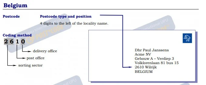
Guidelines for Addressing Mail in Belgium
This document from UPU provides comprehensive guidelines for correctly addressing mail within Belgium. It includes detailed instructions on the format and positioning of the 4-digit postcodes, recommendations for font sizes and spacing, and examples of various address formats, including those for rural areas and P.O. Boxes. The document ensures mail is properly sorted and delivered, offering practical examples for different scenarios and contact information for further assistance.
Universal Postal Union
Postal codes in Belgium - Wikipedia
The "Postal codes in Belgium" Wikipedia Page offers detailed information about the Postal code system in Belgium. This page provides the structure of postal codes, and examples of how they are used across different regions. It serves as a comprehensive resource for understanding the organization and application of postal codes within Belgium.
Wikipedia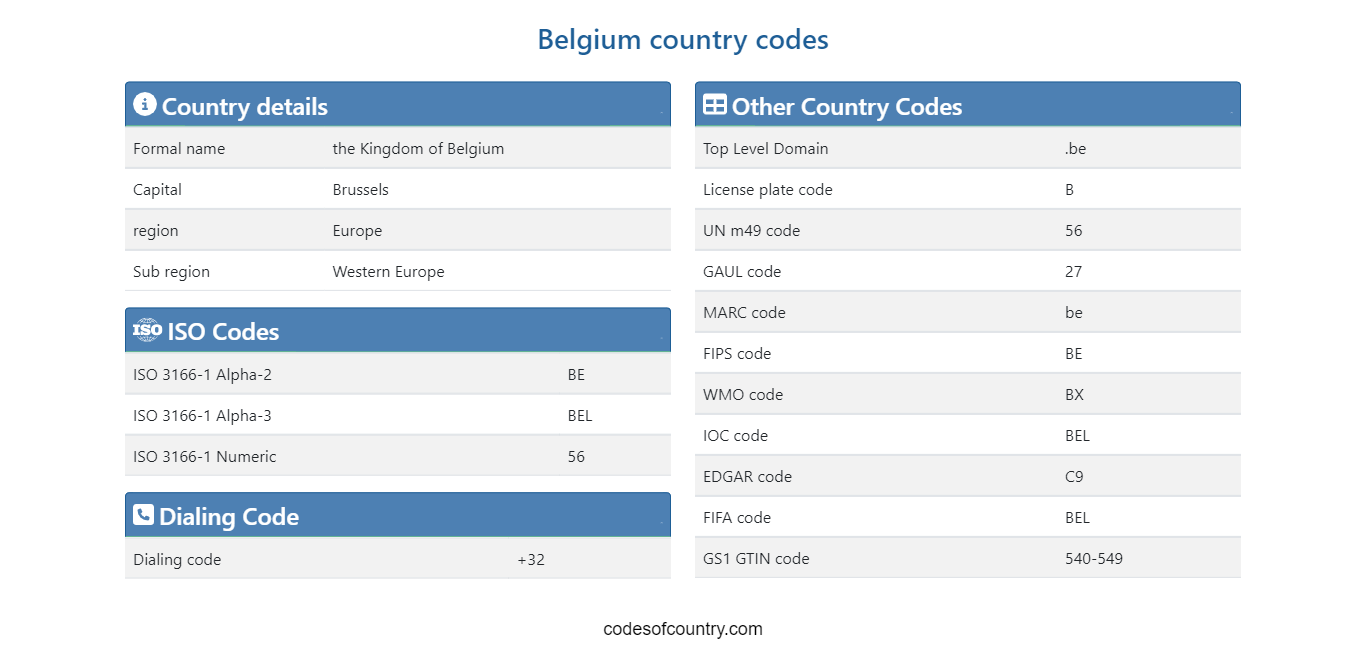
Country codes and Abbreviations - Belgium (BE)
The Belgium country codes Page provides Abbreviations and country codes including ISO codes, dialing codes, TLD, currency codes, time zones, neighboring countries, etc. Access essential information efficiently for streamlined referencing and exploration.
codesofcountry.com
Belgium - Wikipedia
The Belgium Wikipedia Page provides a comprehensive overview of the country, including its history, geography, culture, economy, and more. This page offers detailed information and is regularly updated to reflect the latest developments and insights about Belgium. It serves as a valuable resource for anyone looking to learn more about Belgium.
Wikipedia


